Saturday I was at KWAY bright and early hoping to help with final assembly and prepare for a return flight home early Sunday morning. I collected the loose parts in my hangar and transported to Strope aviation for final assembly.
Alas, there's still plenty more to do on N24286 -- one of the exhaust manifold threads was stripped and thus needs a tap to re-thread, and there is still some assembly required before we can hang the engine on its mount.
I ran around Waynesburg looking for a rare 1-9/16th, 16 threads per inch tap. Even the machine shop couldn't find one, so John will run it up to Washington this week to re-thread.
The engine looks good, though. All valves and springs, rockers, etc are fine and to original spec. The new pushrod tube seals worked perfectly and are nicely seated. The new cylinder head gaskets fit right and sealed under book torque. So far, so good!
Annual inspection is due in October, so I pulled all the inspection plates and floorboards. I lubed all cables, pulleys, and hinges and cleaned the new, flawless LP Aero windscreen. I look forward to seeing lots through it in the coming years.
Around 1330 a C-47 was stopping at KWAY for fuel enroute to Geneseo, NY from Fort Benning, GA where it was used in Regimental ceremony. He did a nice low pass then wheel landed gently on runway 26.


With this guy on the ramp there wasn't much more that would happen on the Chief today.
I decided to fly the Cessna 205 back east so I can take it to Scranton this week for a potential buyer to check out. I planned on taking off no later than 4 on Saturday but when I arrived at the hangar the nosewheel was nearly flat. I couldn't get the air pump to work and after lots of airplane moving and door shoving had to put everything back.
I finally got the pump working and filled the tire with air, but by then it was after 5 and I didn't look forward to a night flight after such a long day. Janet called her friend Jan and she and Scott graciously offered us a room for the night.
We enjoyed a wonderful steak dinner and and evening with Scott and Jan and Andy and Brenda (who live across the street) and turned in late (after 11). I set my alarm for 0600 and it came early!
As I loaded up the car (Janet would drive the car back, I would leave the truck at the airport and fly the 205 back home), I looked up to see stars and moon -- a crystal clear morning. A call to Flight Service gave me some bad news -- Lancaster (5 miles from my destination at Smoketown) was below minimums with 1/4 mile visibility. I haven't flown much IFR this year so am not current to fly IMC. It would have to be VFR for me.
The fog sounded like it was east of Altoona, though so I decided to launch and see how far east I could get.
The airplane started on the second attempt and ran smoothly after a minute warm up. A double check of all systems, a roll out onto Runway 23, and a nice steep climb into the cool, clear air helped me quickly forget all the other work required just to have this privilege.
Somerset was clear, so I elected to refuel at Somerset to wait out the fog. A lineman helped me refuel (unusual these days of self-serve pumps) and I put 30 gallons in ($5.00/ gallon -- a bargain these days).
While waiting a very nice Cessna 206 ( a later model of the airplane I was flying) showed up. It was a Pennsylvania State Police aircraft. The pilot asked me if I was doing pipeline patrol, but I
told him I was ferrying the 205. He said they'd be just south of the airport doing "speed enforcement" -- Beware turnpike travelers!
I checked the KLNS ATIS by phone a few times. When the METAR changed from 1/4 mile visibility to 1/2 it indicated the fog was lifting. By the time I flew the hour out there Smoketown should be VFR. If not, I could divert to the nearest VFR field.
I took off from Runway 25 and depart from midfield downwind towards Indian Lake to the east. I was flying the route I had planned for the Chief. It would be good reconnaissance in a fully equipped GPS aircraft before flying it with just a compass, watch, and map.
Indian lake disappeared under my right wing. Ahead was the Flight 93 Memorial site -- it looks far more groomed then when I visited it on September 20th, 2001.
I maintained a steady compass heading of 92 degrees and soon was nearing the Bedford Aiport (KHMZ). The AWOS there reported 1/4 mile visibility in fog. I was 1500' above it in severe clear.
The next 46 mile leg was the longest without clear landmarks - this would be pure dead reckoning. I maintained heading and watched the turnpike disappear behind the endless central Pennsylvania ridges. I throttled back to 21" manifold pressure and 2200 RPM at 3500', skimming the ridgetops. The airplane loped along at 125 MPH airspeed, 130 knots ground speed. I was in no hurry since I needed time for the fog to lift.
After a while the turnpike reappeared on the right as it followed the valley with the ridge clear to the south. As I flew eastward the highway disappeared after a bend. I checked my chart and confirmed I was about to fly over the twin tunnels (Kittaniny and Blue Mountain) that I'd planned as a checkpoint.
I changed heading to 110, and ahead the sky had a high overcast to the south and a layer of cloud at ground level. I was in haze at 3500' so climbed to 5500' to be at VFR altitude and above the restricted visibility. I called Harrisburg Approach and asked for Traffic Advisories. Some carriers were shooting the ILS at Harrisburg and it sounded tight. I could still see the ground, though, and had plenty of fuel (70 gallons on board when I took off from Somerset) so figured I would divert to York or even Hagerstown, MD if Lancaster was still IMC.
I watched my planned checkpoints roll underneath -- Interstate 81, Route 15, Gifford Pinchot Lake, Interstate 83, the Susquehanna River...
By now it looked clear but hazy over Lancaster so I elected to cancel advisories and begin the descent to Smoketown. Lancaster ATIS had a special weather statement that visibility was now 2 miles in mist, but from my vantage point of 3000' it was clear with just some patchy fog in spots.
I skirted the southern edge of Lancaster city then turned towards Smoketown. The radio was quiet but I did some S turns to check for traffic and lose some altitude. Downwind, base, final, 40 degrees of flaps and some slip and I touched down just past the numbers on 28.
I'm pretty tired from a couple of busy days and short nights, so I'll go for an easy 20 mile bicycle ride, take a shower, and relax watching the Steelers play at 4:15.
Alas, there's still plenty more to do on N24286 -- one of the exhaust manifold threads was stripped and thus needs a tap to re-thread, and there is still some assembly required before we can hang the engine on its mount.
I ran around Waynesburg looking for a rare 1-9/16th, 16 threads per inch tap. Even the machine shop couldn't find one, so John will run it up to Washington this week to re-thread.
The engine looks good, though. All valves and springs, rockers, etc are fine and to original spec. The new pushrod tube seals worked perfectly and are nicely seated. The new cylinder head gaskets fit right and sealed under book torque. So far, so good!
 |
| N24286 Ready for inspection! |
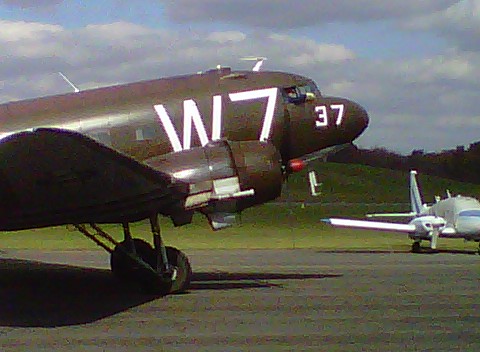
Around 1330 a C-47 was stopping at KWAY for fuel enroute to Geneseo, NY from Fort Benning, GA where it was used in Regimental ceremony. He did a nice low pass then wheel landed gently on runway 26.
 |
| Low pass at Waynesburg |
 |
| Wheel Landing on Runway 26 |
 |
| An image from the Past |


 |
| Setting up chocks for a short layover on the ramp at KWAY |
I decided to fly the Cessna 205 back east so I can take it to Scranton this week for a potential buyer to check out. I planned on taking off no later than 4 on Saturday but when I arrived at the hangar the nosewheel was nearly flat. I couldn't get the air pump to work and after lots of airplane moving and door shoving had to put everything back.
I finally got the pump working and filled the tire with air, but by then it was after 5 and I didn't look forward to a night flight after such a long day. Janet called her friend Jan and she and Scott graciously offered us a room for the night.
We enjoyed a wonderful steak dinner and and evening with Scott and Jan and Andy and Brenda (who live across the street) and turned in late (after 11). I set my alarm for 0600 and it came early!
As I loaded up the car (Janet would drive the car back, I would leave the truck at the airport and fly the 205 back home), I looked up to see stars and moon -- a crystal clear morning. A call to Flight Service gave me some bad news -- Lancaster (5 miles from my destination at Smoketown) was below minimums with 1/4 mile visibility. I haven't flown much IFR this year so am not current to fly IMC. It would have to be VFR for me.
The fog sounded like it was east of Altoona, though so I decided to launch and see how far east I could get.
The airplane started on the second attempt and ran smoothly after a minute warm up. A double check of all systems, a roll out onto Runway 23, and a nice steep climb into the cool, clear air helped me quickly forget all the other work required just to have this privilege.
 |
| Final Approach to Runway 25 at Somerset |
 |
| On the ramp at SG9 |
 |
| Somerset County Airport |
While waiting a very nice Cessna 206 ( a later model of the airplane I was flying) showed up. It was a Pennsylvania State Police aircraft. The pilot asked me if I was doing pipeline patrol, but I
told him I was ferrying the 205. He said they'd be just south of the airport doing "speed enforcement" -- Beware turnpike travelers!
I checked the KLNS ATIS by phone a few times. When the METAR changed from 1/4 mile visibility to 1/2 it indicated the fog was lifting. By the time I flew the hour out there Smoketown should be VFR. If not, I could divert to the nearest VFR field.
I took off from Runway 25 and depart from midfield downwind towards Indian Lake to the east. I was flying the route I had planned for the Chief. It would be good reconnaissance in a fully equipped GPS aircraft before flying it with just a compass, watch, and map.
 |
| Fog filled most of the valleys |
 |
| The Fall colors were past peak in the mountains |
 |
| Fog, fog, fog... |
 |
| Seven Springs Ski Resort |
Indian lake disappeared under my right wing. Ahead was the Flight 93 Memorial site -- it looks far more groomed then when I visited it on September 20th, 2001.
I maintained a steady compass heading of 92 degrees and soon was nearing the Bedford Aiport (KHMZ). The AWOS there reported 1/4 mile visibility in fog. I was 1500' above it in severe clear.
The next 46 mile leg was the longest without clear landmarks - this would be pure dead reckoning. I maintained heading and watched the turnpike disappear behind the endless central Pennsylvania ridges. I throttled back to 21" manifold pressure and 2200 RPM at 3500', skimming the ridgetops. The airplane loped along at 125 MPH airspeed, 130 knots ground speed. I was in no hurry since I needed time for the fog to lift.
After a while the turnpike reappeared on the right as it followed the valley with the ridge clear to the south. As I flew eastward the highway disappeared after a bend. I checked my chart and confirmed I was about to fly over the twin tunnels (Kittaniny and Blue Mountain) that I'd planned as a checkpoint.
I changed heading to 110, and ahead the sky had a high overcast to the south and a layer of cloud at ground level. I was in haze at 3500' so climbed to 5500' to be at VFR altitude and above the restricted visibility. I called Harrisburg Approach and asked for Traffic Advisories. Some carriers were shooting the ILS at Harrisburg and it sounded tight. I could still see the ground, though, and had plenty of fuel (70 gallons on board when I took off from Somerset) so figured I would divert to York or even Hagerstown, MD if Lancaster was still IMC.
I watched my planned checkpoints roll underneath -- Interstate 81, Route 15, Gifford Pinchot Lake, Interstate 83, the Susquehanna River...
By now it looked clear but hazy over Lancaster so I elected to cancel advisories and begin the descent to Smoketown. Lancaster ATIS had a special weather statement that visibility was now 2 miles in mist, but from my vantage point of 3000' it was clear with just some patchy fog in spots.
I skirted the southern edge of Lancaster city then turned towards Smoketown. The radio was quiet but I did some S turns to check for traffic and lose some altitude. Downwind, base, final, 40 degrees of flaps and some slip and I touched down just past the numbers on 28.
I'm pretty tired from a couple of busy days and short nights, so I'll go for an easy 20 mile bicycle ride, take a shower, and relax watching the Steelers play at 4:15.
No comments:
Post a Comment
Thank you for taking the time to comment!