Tuesday, October 25, 2011

Nice Commute!

Had a nice morning flight today. Departed Smoketown (S37) and flew east to Brandywine Airport (KOQN), which is 5 miles south of the Perficient office.

The airplane started easily, and I let it warm up a bit. Curtis was stopping by to drop off the new registration for his C150. We talked for a few moments with the engine running and I told him I'd try to get him and Rick up for a ride this week, weather permitting.

Taxi down, good runup (new plugs help keep mag drop within 50 RPM), and pull out onto 28. I've been flying in the C150 with Rick from Smoketown, so I was pleasantly surprised by the steep climb angle the 205 produced lightly loaded in the cool, clear air.

Morning Haze over farmland east of Lancaster, seen from 3000 feet (2600' above the ground)


I climbed to 3000 and leveled off, throttling back to 20" MP/ 2200 RPM for the short flight. It was a crystal clear fall morning, with light winds which will develop stronger gusts as the day progresses. In 20 minutes I was entering an extended left downwind at Brandywine. The strip was surrounded by suburban sprawl, but looked inviting. I set it down gently a bit longer than planned, but a smooth landing nonetheless.

Push back, tie down, and leave the credit card for 20 gallons of fuel. I called a co-worker who was commuting from Delaware and caught a ride into the office.

After work I'll be flying up to Scranton/ Wilkes-Barre Airport for a pre-buy inspection. Then a night return to Smoketown.


Sunday, October 23, 2011

The Saga Continues...

Saturday I was at KWAY bright and early hoping to help with final assembly and prepare for a return flight home early Sunday morning. I collected the loose parts in my hangar and transported to Strope aviation for final assembly.

Alas, there's still plenty more to do on N24286 -- one of the exhaust manifold threads was stripped and thus needs a tap to re-thread, and there is still some assembly required before we can hang the engine on its mount.

I ran around Waynesburg looking for a rare 1-9/16th, 16 threads per inch tap. Even the machine shop couldn't find one, so John will run it up to Washington this week to re-thread.

The engine looks good, though. All valves and springs, rockers, etc are fine and to original spec. The new pushrod tube seals worked perfectly and are nicely seated. The new cylinder head gaskets fit right and sealed under book torque. So far, so good!

N24286 Ready for inspection!
Annual inspection is due in October, so I pulled all the inspection plates and floorboards. I lubed all cables, pulleys, and hinges and cleaned the new, flawless LP Aero windscreen. I look forward to seeing lots through it in the coming years.

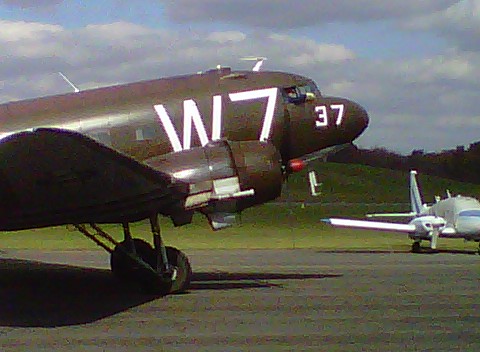
Around 1330 a C-47 was stopping at KWAY for fuel enroute to Geneseo, NY from Fort Benning, GA where it was used in Regimental ceremony. He did a nice low pass then wheel landed gently on runway 26.

Low pass at Waynesburg
Wheel Landing on Runway 26

An image from the Past


Setting up chocks for a short layover on the ramp at KWAY
With this guy on the ramp there wasn't much more that would happen on the Chief today.

I decided to fly the Cessna 205 back east so I can take it to Scranton this week for a potential buyer to check out. I planned on taking off no later than 4 on Saturday but when I arrived at the hangar the nosewheel was nearly flat. I couldn't get the air pump to work and after lots of airplane moving and door shoving had to put everything back.

I finally got the pump working and filled the tire with air, but by then it was after 5 and I didn't look forward to a night flight after such a long day. Janet called her friend Jan and she and Scott graciously offered us a room for the night.

We enjoyed a wonderful steak dinner and and evening with Scott and Jan and Andy and Brenda (who live across the street) and turned in late (after 11). I set my alarm for 0600 and it came early!

As I loaded up the car (Janet would drive the car back, I would leave the truck at the airport and fly the 205 back home), I looked up to see stars and moon -- a crystal clear morning. A call to Flight Service gave me some bad news -- Lancaster (5 miles from my destination at Smoketown) was below minimums with 1/4 mile visibility. I haven't flown much IFR this year so am not current to fly IMC. It would have to be VFR for me.

The fog sounded like it was east of Altoona, though so I decided to launch and see how far east I could get.

The airplane started on the second attempt and ran smoothly after a minute warm up. A double check of all systems, a roll out onto Runway 23, and a nice steep climb into the cool, clear air helped me quickly forget all the other work required just to have this privilege.

Final Approach to Runway 25 at Somerset
Somerset was clear, so I elected to refuel at Somerset to wait out the fog.  A lineman helped me refuel (unusual these days of self-serve pumps) and I put 30 gallons in ($5.00/ gallon -- a bargain these days).
On the ramp at SG9

Somerset County Airport

While waiting a very nice Cessna 206 ( a later model of the airplane I was flying) showed up. It was a Pennsylvania State Police aircraft. The pilot asked me if I was doing pipeline patrol, but I
told him I was ferrying the 205. He said they'd be just south of the airport doing "speed enforcement" -- Beware turnpike travelers!

I checked the KLNS ATIS by phone a few times. When the METAR changed from 1/4 mile visibility to 1/2  it indicated the fog was lifting. By the time I flew the hour out there Smoketown should be VFR. If not, I could divert to the nearest VFR field.

I took off from Runway 25 and depart from midfield downwind towards Indian Lake to the east. I was flying the route I had planned for the Chief. It would be good reconnaissance in a fully equipped GPS aircraft before flying it with just a compass, watch, and map.
Fog filled most of the valleys

The Fall colors were past peak in the mountains

Fog, fog, fog...
Seven Springs Ski Resort

Indian lake disappeared under my right wing. Ahead was the Flight 93 Memorial site -- it looks far more groomed then when I visited it on September 20th, 2001.

I maintained a steady compass heading of 92 degrees and soon was nearing the Bedford Aiport (KHMZ). The AWOS there reported 1/4 mile visibility in fog. I was 1500' above it in severe clear.

The next 46 mile leg was the longest without clear landmarks - this would be pure dead reckoning. I maintained heading and watched the turnpike disappear behind the endless central Pennsylvania ridges. I throttled back to 21" manifold pressure and 2200 RPM at 3500', skimming the ridgetops. The airplane loped along at 125 MPH airspeed, 130 knots ground speed. I was in no hurry since I needed time for the fog to lift.

After a while the turnpike reappeared on the right as it followed the valley with the ridge clear to the south. As I flew eastward the highway disappeared after a bend. I checked my chart and confirmed I was about to fly over the twin tunnels (Kittaniny and Blue Mountain) that I'd planned as a checkpoint.

I changed heading to 110, and ahead the sky had a high overcast to the south and a layer of cloud at ground level. I was in haze at 3500' so climbed to 5500' to be at VFR altitude and above the restricted visibility. I called Harrisburg Approach and asked for Traffic Advisories. Some carriers were shooting the ILS at Harrisburg and it sounded tight. I could still see the ground, though, and had plenty of fuel (70 gallons on board when I took off from Somerset) so figured I would divert to York or even Hagerstown, MD if Lancaster was still IMC.

I watched my planned checkpoints roll underneath -- Interstate 81, Route 15, Gifford Pinchot Lake, Interstate 83, the Susquehanna River...

By now it looked clear but hazy over Lancaster so I elected to cancel advisories and begin the descent to Smoketown. Lancaster ATIS had a special weather statement that visibility was now 2 miles in mist, but from my vantage point of 3000' it was clear with just some patchy fog in spots.

I skirted the southern edge of Lancaster city then turned towards Smoketown. The radio was quiet but I did some S turns to check for traffic and lose some altitude. Downwind, base, final, 40 degrees of flaps and some slip and I touched down just past the numbers on 28.

I'm pretty tired from a couple of busy days and short nights, so I'll go for an easy 20 mile bicycle ride, take a shower, and relax watching the Steelers play at 4:15.

Tuesday, October 18, 2011

No Electric, IMC

[I originally posted this on a pilot web board after it happened  in July 2010]
--------------------------------------------------------------------------------
I learned the hard way why we train in degraded modes.

I planned to sit right seat with an IR student down to NC and I was going to fly it back. This was a very well equipped Cessna 205 with thorough annual completed a few weeks ago.

I arrived early and watched ceilings lower as lines of widely spread thunderstorms crawled through the area. We had XM and Stormscope on board, so we'd have updated info. I did a thorough weather brief, and figured we'd be in front of the line as long as we were airborne by 0600.

Preflight, load up, call Pittsburgh Approach a few times on the cell for an IFR clearance, finally get through. Release time 0620 -- That will work.

Startup, taxi down, runup, everything good -- yet the XM weather on the Garmin handheld still shows "Waiting for data." Oh well.

Stormscope shows lots of activity just to the south. We'll have to ask to deviate east once we contact Center.

We launch and within a minute are in IMC, and despite winds in the 20s, it's not too rough. Still, the left seater isn't doing a very good job keeping wings level. I point to the attitude indicator. We roll through level and then head the other way. Such is learning -- I'll only interfere if bank exceeds 15 degrees or so.

I try calling Cleveland center -- nothing. Hmmm. We usually make contact by now...

Lots of bright lights on the Stormscope. We need to deviate soon. The closest strike is within 25 miles.

Try again. We're at 3500, cleared to 5,000 feet, but still no response from Cleveland Center.

Hmmm...

"Let's try Pitt approach..."

Silence.

Clarksburg Approach?

Silence.

I reach for the landing lights, switch them on then off and watch the Ammeter needle center slowly.

Hmm....

I glance at the panel. We're in a 30 degree bank.

"Let's turn on the A/P while I figure out this comm problem..."

"OK..." Relief. Wings level.

I fiddle with the radios, try different frequencies -- nothing. Not a peep.

Very strange.

I look at the AI -- We're in a 30 degree bank!!

What??!

I switch off the A/P, grab the yoke, tell my student "My airplane."

I look over and try to figure out why the A/P is freaking out. But while doing that I don't correct the bank, then hear the Voice in My Head -- "FLY THE AIRPLANE!"

Oh yeah... wings level, descent arrested.

Now -- where are we?

I switch off the transponder, secondary comms, all lights. The panel-mounted Garmin 430 is still working, so is the 496 handheld.

"Set up Direct Connellsville on the handheld." My left-seat co-pilot complies.

I dial in the Localizer 5 Approach into KVVS on the 430. We have no radio reception, but the overlay will provide enough guidance to get us down under this cloud.

We are over terrain that reaches 3000' -- I'm at 3500'.

I climb to 4000, then fly direct to the initial approach fix displayed on the GPS. The VOR needles won't work since we have no power in the radios.

The little airplane shows up on the magenta line. We're on battery power only and the handheld has the same approach setup. I do the full procedure turn, descending to the approach altitude, We're established, but not on any needle -- no signal.

All we have is the GPS guidance. This is not a "legal" GPS overlay approach.

So be it.

We break out at 2100 MSL -- a few hundred feet above Minimums (the terrain here is 1400-1500' above sea level). Thank you Lord for sight.

I fly a left downwind, "You want to land it?"

"No, you take it."

I land a bit fast and long but smoothly in the gusty 20+ knot wind. I let him taxi back because I had enough.

Once stopped, I hop out and call ATC to cancel.

They seem as relieved as we are: "Yeah, we were wondering what happened..."

We put the airplane away, open up the cowling -- holy crap -- there are shards of belt everywhere. Nice.

I drove home and crawled back in bed and slept for a few hours, thankful to have another day to think about how many mistakes I've lived through.


Lessons learned?

  • Make sure you can hear some transmissions before taking off into IMC. Sure, we were on a quiet little field early in the morning, but other ATIS would have been broadcast at that time (even if ours was out of service).
  • The A/P cannot be relied on to reduce pilot load when there are system problems.
  • A handheld GPS device with independent battery and approaches is a lifesaver.
  • Practice emergencies. They don't happen when you expect them, and are more likely when you don't expect it.
  • The time to panic is after you're on the ground, pushing the airplane back in.
  • This stuff is for keeps.

Monday, October 17, 2011

Wind, wind, wind....

We've been in the midst of a steady wind here the past few days. It feels like our corner of Pennsylvania was dropped onto the great plains.

Hopefully the winds will calm down by the weekend so I can fly the Chief home!

Thursday, October 13, 2011

Online Flight Planners

There are now several decent online flight planners to use. Some free, some with a nominal charge.

While I still enjoy laying out sectionals and drawing with a pencil, I also like to experiment with different routes, check on airports, and double-check my pencil and paper work with computer-aided calculations.

I provide a summary that looks like this:

Flight Planner Name
  • Cost?
  • Ease of use:  1-10 scale, 1 being stupid hard, 10 being 5 year old easy, the rets is somewhere between those extremes
  • Accuracy: How good is the information produced?
  • Output usefulness in Flight: Does it provide kneeboard print outs et cetera that are actually useful in the cockpit?

So here is my biased, slightly informed review of Flight planners I have used:
(If there is one I should use, send me a link!)

AOPA Flight Planner
  • AOPA membership required 
  • Ease of use: 9, this is the easiest by far, in my opinion.
  • Accuracy: 8, it's pretty good, though closed airports still show up as options (Seven Springs, for example)
  • Output usefulness in Flight: 7, there's a nice nav board with all the requisite data, but a print out of all airport info along the route of flight would be much awesome.
My only complaint is the lack of satellite (Google Earth or Bing Maps) view. I'm sure it would be a whopping licensing fee but it's nice to dream. as a low-level flier satellite imagery really helps prepare for flight over new terrain.


NavMonster
  • Free 
  • Ease of use: 8 -- this is fairly easy and intuitive, but page changes lose context.
  • Accuracy: Seems to provide good info, but lack of sectionals is disappointing.
  • Output usefulness in Flight: 8, the trip kits are the best of all web-based planners.
Excellent overall planning tool -- .well done!!


EAA Flight Planner
  • EAA membership required 
  • Ease of use: 5 -- there are simply too many varied screens, with all sorts of suggestions that you update to "Premium." Oh, ok. Maybe not
  • Accuracy: Seems to provide good info.
  • Output usefulness in Flight: 8, the trip kits are nice, though paper and ink hogs.
Sorry, but this one is just too busy with too much changing context. Consider me spoiled be good (e.g. consistent) interfaces.


SkyVector
  • Free, registration required 
  • Ease of use: 7, pretty simple, but limited in info and too many overlay screens that lose context ("what just happened? OH! There's a tab -- over what I was doing...")
  • Accuracy: Seems ok -- sectionals are current.
  • Output usefulness in Flight: N/A (Haven't used this in flight)
My first choice for just messing around, looking at sectionals. I don't want to enter a flight plan -- I just want to see what's where, how far from here to there, and what it looks like from the air.


Runway Finder
  • Free, registration required 
  • Ease of use: 8, pretty simple,and somewhat easier than SkyVector.
  • Accuracy: Seems ok -- sectionals are current.
  • Output usefulness in Flight: N/A (Haven't used this in flight)
Toss up between this and SkyVector. I use each about the same.


FlightAware
  • Free, registration required 
  • Ease of use: 4,  limited in info and too many changing contexts. I lost interest in trying it, quite frankly.
  • Accuracy: Seems ok -- sectionals are current.
  • Output usefulness in Flight: N/A (Haven't used this in flight)
Nice for tracking flights or keeping folks I'm flying IFR to see my progress, but not much use for VFR low level flying.


FltPlan.com
  • Free, registration required 
  • Ease of use: 4,  limited in info and too many changing contexts. I lost interest in trying it, quite frankly.
  • Accuracy: Seems ok -- sectionals are current.
  • Output usefulness in Flight:  I haven't used fltplan.come stuff in flight for at least 5 years. It was good then, but newer web-based planners have made this obsolete for my use.
One of the oldest, but showing its age. The interface is cluttered, errors are not adequately flagged (you are not alerted and thus cannot proceed at certain steps), the aircraft performance list is limited and there is no way to build a custom aircraft entry.
I used it years ago, but it's off my list of flight planners.


Flight Prep
Are you kidding? never in a million years....


2011 Annual

This year's maintenance focused on the engine. While there were no major oil leaks or power problems, there was one nuisance leak and I simply wanted the engine opened up and inspected thoroughly and all gaskets replaced. One pushrod tube seal had a leak and it wasn't getting better. It dripped from the seal onto the exhaust pipe - not a good thing.

Once we pulled the engine we found one cylinder had blow-by. It's hard to tell if it's constant or merely on startup (cylinder may warm and compress gaskets reforming the seal between the head and the base). So back in May we pulled the engine off and John opened it up. The news was very good -- all valves, rings, pistons, lifters -- the works -- were in good shape, with no abnormal wear or deformation.

I ordered one set of gaskets and manufactured another (.020 copper gaskets) The pushrod tube seals were another matter. One quote was $26 each -- for 16 (these seals are mere 1" rubber O rings). So I tried owner manufactured, but could not get the lip right.

Finally I found a source for 14 in Atlanta for $14 each. I ordered the balance from Tulsa, OK for $24.50 each. So John is re-assembling the engine this week. This means all hoses, gaskets, lines, and mounts will be new. All spark plugs will be mounted in heli-coils for added security.

Of course we'll pull all the inspection plates, floor boards, etc,  but this should be a simple annual after the work we've accomplished in the past 18 months.

I'm looking forward to test flying it. If all checks out I'll fly it across Pennsylvania to its new home!

Tuesday, October 11, 2011

Neat resource! WW2 Naval booklet for instrument pilots in training. http://aviationshoppe.com/manuals/flight_thru_instruments/naval_flight_manual.html

Latest Update

I talked to John Strope, my patient and knowledgeable A&P who is putting my engine back together with all new gaskets.The schedule right now is to get the engine on the airframe this Saturday, with the Annual complete next week. That's fine since the current forecast is for 25-35 MPH winds on Saturday and 20 MPH winds Sunday. No fun flying an 800 lb airplane in those conditions! If it's not too bad I may fly the Cessna 205 out for a potential buyer in Scranton, PA. So realistically some time next week the Chief wil come home! I've done all the flight planning. KWAY to S37 (Somerset, PA), stop and re-fuel after 45-50 minutes. Then S37 to S39 via KHMZ, then the Sideling Hill Turnpike rest Area (very good landmark), then remain north but parallel to the Turnpike. Once I clear the last tunnels, direct to S37 (Smoketown) for 2 more hours in flight. There are two small restricted areas just south of the route of flight that I need to avoid (they are part of the Letterkenny Army Deport Test Range). Staying north of the turnpike until all tunnels are cleared will assure plenty of clearance.

Tuesday, October 4, 2011

A Long Stretch

I was finally able to secure the last remaining gaskets for my antique engine. 4 have arrived at Strope Aviation and the rest (12 more) should be there today. I still have one of the pushrod tubes (used it to measure and cut ill-fated gaskets) but will be back out west this Friday.

John thinks he can get the engine back together this week, which means I may be flying it home next weekend!

My new airport home is Smoketown Airport,\ (S37) just east of Lancaster on Old Philadelphia Pike. It's about a 15 minutes drive from our place in Mount Joy. It's a small-town airport with enough level turf to make it perfect for my antique taildragger.

I know the area well and am looking forward to low and slow flight over the endless patchwork of Lancaster County farms.

Wednesday, August 24, 2011

Learning to Land

Those of us who have been flying a while and have hundreds or thousands of landings logged have a hard time remembering how many balls have to be juggled to successfully land an airplane.

We also forget how rugged training airplane gear is. So once in a while a student working on his or her first landings will bring all that back, and remind us why non-fliers think landing is the hardest part of flying. In some ways, it is.

A successful, smooth landing with minimal ground roll requires minor course corrections to maintain centerline, descent at specific airspeed and configuration, and a smooth transition to level flight a foot above the surface. All this happens as the control effectiveness is reduced by changing speed, and wind variations caused by trees and houses and hangars change steady winds at 100 feet into tumbling, variable, unpredictable cauldrons at ground level.

Meanwhile, the very thing that we takeoff to avoid -- the ground -- is fast filling the windscreen.

So take a moment to remember the challenges of landing, and give a student a break next time you're sharing the pattern and he or she flies bit wide to take more time to line everything up just so. There's lots going on!

Thursday, August 11, 2011

Nice Morning Flight over Lancaster County

Took some pictures with my Blackberry while flying over Lancaster during instruction.

Over the Susquehanna River, York County on the far bank.

Looking northwest towards Lancaster City from 3000 feet.

Route 30 Business just east of Lancaster. Rockvale and Tanger outlets below.

The black line is the propeller flashing through as the image was taken.

Smoketown Airport

Sunday, July 31, 2011

Beautiful Morning Over Lancaster County

Took a few pictures while flying over Lancaster early this morning during a lesson:


Rick did the takeoff with a bit of assistance, then we did slow flight, stalls, 360 turns at 30 degrees, emergency procedures (Glide, Grass, Gas), and ascending turns and entering the traffic pattern.

It's amazing how quickly an hour goes by in the air!

Monday, July 25, 2011

Return to the sky

It's been a very busy spring. I took a new position as a senior Solutions Architect with Perficient working in the Exton, Pennsylvania office (and at various client sites within 100 miles of Exton).

For three months I commuted each Monday morning from Western Pennsylvania to Exton until we could sell our house and move. The market is as bad in Fayette County as anywhere else, so after very little activity and no offers, we put the house up as a rental.

We finally discovered a very nice apartment complex in Mount Joy (Crest at Elm Tree) and moved in June 8th (at 94 degrees, it was fairly hot to be moving furniture!)

Of course all this commuting and moving cramped my flying time, so I logged only 2 hours from April to June!

We returned to Fayette County, moved some more stuff from our house to storage in my hangar, and spent June 11th celebrating our grandson Luca (1) and our son Nathaniel (21) birthdays. Sunday I met Bill and we flew the C205 from VVS to WAY for an annual.

I've reconnected with some former students from my LCS teaching days and a couple have expressed an interest in flying. Jeane's husband Curtis has a C150 at Smoketown (S37). After some weather and conflicting schedule problem we finally had time to fly this Saturday.

Smoketown is a nice little strip tucked in along Old Philadelphia Pike just east of Lancaster. I had flown here a few times and knew the airport, but it's been while.

Curt gave me the background on the airplane, then did a thorough preflight. The airplane could use some P&I but mechanically it is sound.

I said I'd be fine in the right seat and then we did the usual Cessna 150 gymnastics to get in and belted, then started it up. It started on the first flip of the magneto and then hummed contentedly -- an auspicious start.

Curt said, "It's yours!" I said, "Oh, I thought you were going to fly...?"

I didn't argue, pushed in the power and we rolled onto the taxiway.

The airport was quiet. Dark clouds hovered just south and a higher layer obscured most of the sky, but there were no radar returns within 100 miles and the forecast was benign. It was warm already but not hot enough to cause high DA conditions.

A quick runup, all systems go, lined up, elevator down into the slight right crosswind, and rolling. The airplane responded well and we were airborne long before the abort point.

Even though there was a slight breeze there was no turbulence on climb out -- quite a change from Western PA and WV flying, where the slightest wind burbles over every little hill, ridge, and valley ensuring a fun ride for the first 1000 feet. It was my first time in this airplane so I turned right towards large, flat farm fields just north of the railroad tracks along the edge of the airfield. We continued climbing, and I leveled off at 1500'. With full power and level we reached 90 MPH -- not bad (probably not a climb prop on here).

I practiced some steep turns, slow flight, etc to get a feel for the airplane, then we did some sightseeing over southern Lancaster county and the Susquehanna river.

Too soon we headed back, entered a left downwind on a 45, and made a full-flap landing just past the numbers on 28. I was a bit surprised I had the sight picture down -- I was sure I'd be rusty (especially since it's been about a year since I even sat in a 150 and about 10 since I flew one -- and never from the right seat).

We tied down and locked up, then visited with Marlin Horst, airport owner and airplane restorer. He has pristine flying J-3 and Waco, and a Fairchild -71 in being restored. He also showed me a Lycoming O-145 over on the engine pile (discovered and purchased at auction).

Curtis and I scheduled more flying time for his son Rick who is just starting out. It will be fun to do primary training again!

I headed over to the FBO building and got re-acquainted with Mel Glick, now the airport manager (and former owner). No hangars available yet for the Chief but I'm on the short waiting list. We'll see...

I had stuff to do at home so bid adieu and headed west to Mount Joy. But it feels good to be reconnected not only to flying, but to the whole community that forms around our obsession and is best experienced at a small field.

Tuesday, February 22, 2011

A Morning Commute

I considered flying to work and back today, but forecast winds 15G25 gave me pause.

But at 6 AM, the air was clear, crisp, and still.

I drove straight to the airport before work, did a quick preflight, pulled the airplane out into the sun, tied the tail down, primed, spun, checked and tossed and soon the mighty Lycoming was puttering like my beagle when she's ready for a walk.

Untie, unchock, climb in, check oil once more, turn on radio -- ugh.

Oh well. It's early, no one else is out, and I have a spare AA battery carrier on board.

There’s the slightest breeze wafting in from the west. Runup good, check the sky, point west.
The tail comes up and soon the earth falls away.

The air is smooth and very clear – unusually so, even for a spring day. As I climb to 2500’ or so, I notice steam plumes from the powerplants bent to the northwest.

Level and cruising at 80 MPH, the ground creeps by at a snail’s pace. I check ground speed using the ultra-sophisticated “Look at the cars on the highway” method: ok, 55, maybe 60.

Even though the wind is from the southeast, the ride is smooth. That’s also unusual here, since southeast and easterly flows bounce across the washboard Alleghenies, making for unpleasant aviating. I continue east, dive a bit once over the fog shrouded Monongahela, and head towards the house.

Over the past few weeks the landscape has transitioned from nascent to full-on, riotous green. Trees shoulder one another with broad, leafy arms, fields bloom, and ponds and lakes wake to dustings of seeds and pollen.

From my vantage point above it all, the all-pervading sense is peace and stillness. Even cars look unoccupied and somehow natural, like beetles scurrying from one log to another on the forest floor. The birds haven’t yet climbed up, the dust and clouds and winds of the more mature day are yet to come. In my tiny fabric covered airplane, I am in control, and can go where I will, with simple nudges that would barely rouse a cat.

But the sensation is illusory – I slide open the side window some more and feel the wind blast, hear the engine putting. All that keeps me here is force and power – the burning of fuel and the mastery of aerodynamic forces that compel this heavy object into the sky work in concert, but only temporarily.

The familiar hills, water tower, and houses. I see Janet on the deck. How can all that I love in this world be contained in such a small space? This weekend our house will be filled with our children and our granddaughter. It looks too small, too frail, too miniscule for the weight of meaning placed within those old walls.

I wave, do a few low altitude turns about a point and then a zoom climb back to 2500’ on an easterly heading, towards the Summit (a 1930’s era landmark restaurant/hotel at the summit of Chestnut Ridge along Route 40, the first National Highway).

Bumps begin. The wind was still right on the nose and I slowed even more as I approached the west side of the ridge. I imagine all that air cascading down the face of the ridge like Niagara Falls, tumbling, and rolling. Still, the bumps are light and the cascade is more like a gentle stream flow than a torrent.

I look at my watch – I hate weekdays – and turn west. I push the nose forward and enjoy the speed – maybe 100 MPH groundspeed? – cars fade in my wake.

I turn on the radio and listen. One of my students is flying this morning.

I announce five miles east of the field. An inbound Cherokee announces 10 miles out. I let him know my intentions, push the nose down a bit more.

“Greene County traffic, Chief 24286, straight in 27 for the grass, Green County.”

I skim over the tree tops, pull power to idle, crank in trim, give a few slips just for grins, and touch down gently on the grass, decimating dandelions and spraying dew on struts and wings.

The restaurant is busy. I’m sure at least a few observers critique my landing. No mind. Taxi to the hangar, cut off the fuel, let it idle at 1000, putt-putt….

Click, click as the engine cools and I push the airplane back into its den. The breeze is freshening. By nightfall this beautiful, clear sky will be filled with rumbling, dark, malevolent energy roaring in from the west.

But not yet.

Engine is Off

We pulled the engine off last week and it's sitting on a stand slowly leaking tiny drops of oil still clinging to the block. The rest of the airplane is in the hangar looking forlorn. I started removing all the firewall and engine mount paint. I'll repaint it all in high-heat black.

The engine needs some new gaskets. The valves will be checked for clearances -- hopefully they all pass! (Replacements are rare and likely very expensive).

After this round of maintenance I should have a reliable, non-leaky airplane!

Saturday, January 22, 2011

Frustrating Winter

This winter has been a near repeat of last -- cold, snowy, gray, and windy.

The Cessna 205 hasn't sold yet, and interest has been minimal. We still have to replace the battery and get the autopilot re-installed by the guys at ProAv in Ohio.

The Chief sits... and sits. When it's VFR, it's windy or the runway is snow covered. Last weekend I found my taxiway un-plowed. I'll shovel the pad in front of the hangar but 400' of taxi is just too much.

The prop is on in the last possible position. If this doesn't take care of the vibration, the prop will come off and go the Sensenich for an overhaul ($550).

I already have February 15th listed as engine pull-off day at Strope AC Maintenance. We'll pull the O-145-B2 off and replace all the seals (pushrod seals are leaking causing oil to slowly creep all over the engine compartment).

We'll also check the valves.

I'll feel better flying longer distances this spring and summer with the leak stopped and the valves checked.

Thursday, December 16, 2010

Sunday, December 12, 2010

Waynesburg-Greene County Airport (KWAY)

Looking east from 2500' (About 1400' above the ground)
I'm now the AOPA Airport Support Network volunteer for the Waynesburg Airport (KWAY).

From AOPA:
Pressure on public and privately owned airports continues to mount. This pressure takes many forms, including curfews, noise restrictions, lack of improvements, residential encroachment, and even calls to close the airport.
Often, the general aviation community is totally unaware of what's boiling in the pot concerning their airport—until it is too late to turn the tide. Knowing what's happening in the political environment surrounding a local airport is of the utmost importance if we are going to preserve our general aviation infrastructure into the foreseeable future. The more time available in which to counter negatives about a local airport, the higher the possibility for preserving the airport or avoiding restrictions.
The AOPA Airport Support Network provides the vehicle for AOPA members to work in concert with AOPA to establish that early warning system.

Saturday, December 11, 2010

Another Gorgeous Saturday

Winter's paid us a few visits so far, but Saturdays have been exempt, lately.

It warmed up to near 50 under clear skies and light winds -- the calm before the storm, since we're to get blizzard conditions within 48 hours.

Such is December in Southwest Pennsylvania.

I headed to the airport early and found the airplane snug and warm after a night with blankets and a heater under the engine. I fueled up, preflighted,  pulled the airplane into the sun, tied down, primed, pulled the prop through, mags to hot -- started on first throw!

I taxied down to 27 even though winds were calm to give the engine time to warm. Took off, overflew the airport, and headed east.

The air was a bit hazy so I used carb heat from time to time, but engine was running strong and we were crusing along at 80 MPH.

I texted Janet, told her "5 minutes" and she was waiting for me outside in front of the garage. I did a few low passes over the house -- sure was fun! I had to dodge the hill behind the house and didn't want to stick around too long lest a local get upset.

I wish Janet could have come along this morning -- it was smooth as glass and I didn't have to climb too high. Most of the time it was like looking out from a balcony in a tall apartment building.

Westbound about 500' above the ground

Flying along the valley in front of the house


The view from 500' Above the Ground.

Lots of rolling hills with remnants of snow. The black line is the prop as captured by the camera (it's turning about 38 times a second here)

Greene County, Pennsylvania

Back in the hangar
I headed Northeast, skimmed over Route 51, then flew towards Connellsville.

The river looked cold below with ice floes visible from above. I did some nap of the earth flying over some more remote areas then headed generally Southwest.

An hour and fifteen minutes today -- until next time!

Sunday, December 5, 2010

First Winter Flight


Friday I checked the weather a few times and it looked like there would be a hole Saturday morning (the past week has been non-stop cold, gray, and light snow).

I stopped by the hangar Friday evening after work and hooked up the engine pre-heater (two 100w bulbs in trouble lights, two moving blankets, a carpet remnant, and an old army duffel bag wrapped around the cowling with a rope tied off on the prop). I give the bird a pat, take one last look, then turn off the lights and close the big sliding metal hangar door. The lock is cold as I jam it shut and twist the combination dial. I should replace this -- it's going to get water inside and freeze and then I'll be stuck. Note to self -- buy new lock.

I woke early Saturday and looked outside. While the sky was completely overcast, the haze beneath wasn't too bad. a check of the local METARS shows generally decent conditions with lowest reported visibility of 4 miles.

Janet has an all-day event at church today so I leave after she does and drive the truck to Waynesburg. The visibility is variable but VFR all the way. Of course, the airport is sitting in the thickest soup I've seen so far. Oh well -- it will clear.

Of course, the combo lock is frozen. I let the heat from my hands seep into the lock. Make another note -- get new lock.

I push the hangar doors open and light streams in the darkness. The bulbs are still on. I reach underneath the blanket expecting warmth but instead find cold aluminum. Ugh.

I go through my usual pre-flight steps, pull the airplane out into the diffused sunshine which doesn't seem to be coming from anywhere in particular but is slightly brighter than during the drive to the airport. Maybe the layer above is thinner than forecast? Yet there is no blue -- only white in the sky.

I close the doors, tie the tailspring to the truck's tow ring, place chocks in front of the mains, and look around to make sure I haven't forgotten anything.

It's cold, so I leave my hat and jacket on. 4 shots of prime, mags to OFF. Walk around front, push blades through 14 or so times. Walk back, mags ON, walk back, throw -- nothing.

There's are moments during some hand props when you wonder "Should I turn the mags off or move this into position by hand?"

I opt for the move with care. Throw the prop -- nothing.

OK....

Back to the cabin, mags off, another two shots of prime, 4 blades through.

Mags ON, walk back front, throw -- chug, chug.

A satisfying sound, but no guarantee. It's cold out and plugs that fire can get frosted over. I run to the cabin and push the throttle in a bit -- the engine stumbles, then coughs, more cylinders fire.

I ease the throttle in, then back out and the engine settles into its cold routine of heavy chugging at 800 RPM. It's OK -- the light bulbs haven't provided much heat and it's probably 25 degrees out. I stand next to the cabin and my legs freeze in the prop blast. I pull the throttle to idle and it settles at 500 RPM. The tail spring rope untied, I walk back up and reach for the chocks, connected by a 10' rope so I can pull both front mains from the pilots side. I saw someone else do it -- It works!

I'm planning a local flight so the chocks get tossed on the snow-coated grass.

I climb in and bump the throttle to 800 RPM and listen as the engine warms, chugging more regularly, evenly. Good.

I sit and listen to the engine, looking at the gauges. All is well, and now I can relax and enjoy it. All the preparation, planning, and work is done. The airplane is running, everything's been checked -- all that's left is to roll down the taxiway, then the runway, then plunge into the sky.


A blast of power and the airplane moves, the tail wheel straightens, and I check to either side for clearance. A few maneuvers to avoid puddles (I was by an A&P that water splashed up inside a wheel can freeze and lock it in place in the air -- making for a very interesting landing).

The air is a bit less hazy now and the sky seems brighter. Winds are minimal -- the wind sock moves inches, the flag hangs limp. I can takeoff either direction but will taxi to the end of 27 to give the engine more time to warm.

Control checks, trim set -- good. Killdeer walk along the runway -- why are they always on the runway? I taxi into position, straighten the tail wheel, and add power. The birds start to walk quickly to the south side of the runway. But not fast enough. I continue adding power and now the tail comes up. Killdeer fill the bottom of the windscreen -- com'on, birds.... this airplane may be small but that propeller is gonna hurt!

The birds take flight when I'm about 30' away. I feel the wings catching and the airplane is about to take flight as well. The prop bites into the cold air and the airplane is ready to fly. I hold it on a moment more, then release some back pressure. Rolling, rolling, then no sound from the wheels.

We're flying. Birds below now. Oil pressure still good, 2300 RPM -- OK. Pull back a bit and climb at 50, add some trim. I look to the right and pick out a spot to land if I lose power now. To the left and ahead is a parking lot studded with light poles and cars -- only if I have to. Still climbing, I glance at the airspeed and altimeter -- up to 300 feet now. I start a climbing left turn. hold the ball perfectly centered, feel the engine warming, RPM increasing.

Now the airport is under my left wing and the air is hazy, but smooth. I level off about 800 feet above the ground and announce a closed pattern, fly over the field, check all the gauges -- all is good.

Time to head east and fly over the house.

I climb to 2500' (1200' or so above the ground) and clear the river and the fog. Level the airspeed exceeds 80 MPH at 2500 RPM. Nice.

I pull on the carb heat from time to time -- it's an automatic precaution on these hazy days. Carb heat applied RPM drops slightly -- good. Off and RM increases -- good.

I have some fun flying low over New Salem and the house and a few familiar hills. I climb a bit then circle over Uniontown. I'd fly further east but the mountain is barely visible in the haze. I decide to fly along the new highway and reduce power and push the nose over, enjoying the lightness of zero g.
A few hunters are visible from here -- please don't take potshots at my airplane. I'm low enough one could reach.

I zoom over the highway and enjoy the sensation of speed low-level flight. The air is thick with haze, and I keep a close eye on the RPM. So far no carb ice -- good.

I'd fly longer but the cabin heat isn't working very well so I point the airplane along a mostly west until I see familiar landmarks. The water tower near the airport appears and soon I'll be landing. I delay things a bit by climbing and doing some slow flight, then steep turns, then a practice emergency turn back.

300' altitude loss from engine idle to 180 degree change of direction. Of course a turn-back requires more than 180 degrees and there is residual thrust in the idling prop. There is also no recognition delay. But it's fun to push the nose over from climb to glide at 60 while cranking in 60 degrees of bank.

Time for some slow flight fun -- throttle back to 2000 RPM, crank in some trim, and let the airplane settle in at 60 MPH. The engine purrs and it seems the airplane is happier at this speed. Maybe I should do this more often?

55 minutes have passed. It's time to land. I fly south of the field, then do a hard 180 to join mid-field left downwind. I'm at 500' above the ground, but 1000' AGL is to high and there's no one else flying. Touchdown point 45 degrees behind me, throttle to 1500 RPM, slow to 60, crank in full trim, turn left. Slip some and pull throttle to idle. There's the runway. I'll land 1/3rd down to save the endless taxiing. I crank in enough trim to maintain 55 and then pull back to keep it at 50. The ground comes up slowly and soon the wheels touch, all three nearly simultaneously, the tailwheel rumbling on the pavement. I prefer grass but it is frosted this morning.

I taxi to the hangar, shut down, pull the airplane back into the hangar, wipe off the oil, and lock up until next time.