
Saturday, October 29, 2011


N75885

I landed, parked the airplane, and drove home exhausted. Not long after I was home my instructor called and asked, "Did you notice anything wrong with the airplane?"
"No."
"Well, all the engine oil is in the cowling or on the ramp..."
I hadn't noticed anything unusual when I flew it, but when I realized it had no oil, that meant it had maybe 5 minutes of run time before the engine seized and 75885 would become a not-so-great glider.
I didn't rent it anymore after that.


Friday, October 28, 2011
Crash at S37
Well, that didn't work out too well:
http://lancasteronline.com/article/local/487401_Small-plane-clips-tree--crash-lands-at-Smoketown-Airport.html
Pilot is in hospital and alert.
There is a bridge just northwest of the airport. Power lines and some trees follow the bridge which is about 40' higher than the runway surface at its highest.
One eyewitness claimed he saw the airplane "circling around several times." However, this is normal for pilots practicing takeoffs and landings at an airport.
Weather conditions were benign all day. It was clear and sunny all morning, then high clouds (over 10,000' up) covered the area in the afternoon as winds died.
The preferred calm wind runway is 28 (facing west and slightly uphill). Light winds may have shifted from the east around 2 PM. The pilot may have elected to land on runway 10 (facing east) to land into the wind.
The approach to 10 is unfamiliar to most pilots flying n/out of Smoketown as VFR weather usually means winds from the west. Easterly winds usually mean poor weather and most small airplane pilots are confined to fair weather flying.
The runway has a slight slope (uphill facing west, downhill facing east). The downhill slope gives the pilot the illusion that he is actually higher than he really is. Add in the high clouds and muted light and the runway appears even smaller and lower.
The pilot may have been practicing short field landings. To do this the pilot selects a spot on the runway and aims to land on it. The best technique is to pick an aiming spot before the actual landing point since there is always a short period of float before actually touching down. Most pilots use the large numbers as aiming points (easy to see, at the near edge of the runway, etc.) If the accident pilot selected the numbers (10 in this case) then his aim point should have been before the painted 10. Yet this runway has a displaced threshold since there are obstacles that do not permit a normal 3 degree glide slope to the landing surface.
Conclusion: Attempting to land on the displaced threshold, the pilot clipped a tree and lost control of the airplane, impacting the ground 200' of the hangars.
---------END SPECULATION----------------------
The NTSB report is out:
The pilot survived and received multiple stitches and was released from the hospital the same day.
http://lancasteronline.com/article/local/487401_Small-plane-clips-tree--crash-lands-at-Smoketown-Airport.html
Pilot is in hospital and alert.
-----SPECULATION ONLY FOLLOWS--------
There is a bridge just northwest of the airport. Power lines and some trees follow the bridge which is about 40' higher than the runway surface at its highest.
One eyewitness claimed he saw the airplane "circling around several times." However, this is normal for pilots practicing takeoffs and landings at an airport.
Weather conditions were benign all day. It was clear and sunny all morning, then high clouds (over 10,000' up) covered the area in the afternoon as winds died.
The preferred calm wind runway is 28 (facing west and slightly uphill). Light winds may have shifted from the east around 2 PM. The pilot may have elected to land on runway 10 (facing east) to land into the wind.
The approach to 10 is unfamiliar to most pilots flying n/out of Smoketown as VFR weather usually means winds from the west. Easterly winds usually mean poor weather and most small airplane pilots are confined to fair weather flying.
The runway has a slight slope (uphill facing west, downhill facing east). The downhill slope gives the pilot the illusion that he is actually higher than he really is. Add in the high clouds and muted light and the runway appears even smaller and lower.
The pilot may have been practicing short field landings. To do this the pilot selects a spot on the runway and aims to land on it. The best technique is to pick an aiming spot before the actual landing point since there is always a short period of float before actually touching down. Most pilots use the large numbers as aiming points (easy to see, at the near edge of the runway, etc.) If the accident pilot selected the numbers (10 in this case) then his aim point should have been before the painted 10. Yet this runway has a displaced threshold since there are obstacles that do not permit a normal 3 degree glide slope to the landing surface.
Conclusion: Attempting to land on the displaced threshold, the pilot clipped a tree and lost control of the airplane, impacting the ground 200' of the hangars.
---------END SPECULATION----------------------
The NTSB report is out:
The pilot reported to a Federal Aviation Administration (FAA) inspector that, while on final approach for landing, he descended the airplane too low and the airplane's left wing contacted a tree. The airplane veered left and continued to descend before impacting the ground, resulting in substantial damage to both left and right wings and the engine firewall. The inspector's postaccident examination of the airplane revealed no mechanical malfunctions or anomalies.
The pilot survived and received multiple stitches and was released from the hospital the same day.
Tuesday, October 25, 2011
Nice Commute!
Had a nice morning flight today. Departed Smoketown (S37) and flew east to Brandywine Airport (KOQN), which is 5 miles south of the Perficient office.
The airplane started easily, and I let it warm up a bit. Curtis was stopping by to drop off the new registration for his C150. We talked for a few moments with the engine running and I told him I'd try to get him and Rick up for a ride this week, weather permitting.
Taxi down, good runup (new plugs help keep mag drop within 50 RPM), and pull out onto 28. I've been flying in the C150 with Rick from Smoketown, so I was pleasantly surprised by the steep climb angle the 205 produced lightly loaded in the cool, clear air.
I climbed to 3000 and leveled off, throttling back to 20" MP/ 2200 RPM for the short flight. It was a crystal clear fall morning, with light winds which will develop stronger gusts as the day progresses. In 20 minutes I was entering an extended left downwind at Brandywine. The strip was surrounded by suburban sprawl, but looked inviting. I set it down gently a bit longer than planned, but a smooth landing nonetheless.
Push back, tie down, and leave the credit card for 20 gallons of fuel. I called a co-worker who was commuting from Delaware and caught a ride into the office.
After work I'll be flying up to Scranton/ Wilkes-Barre Airport for a pre-buy inspection. Then a night return to Smoketown.
The airplane started easily, and I let it warm up a bit. Curtis was stopping by to drop off the new registration for his C150. We talked for a few moments with the engine running and I told him I'd try to get him and Rick up for a ride this week, weather permitting.
Taxi down, good runup (new plugs help keep mag drop within 50 RPM), and pull out onto 28. I've been flying in the C150 with Rick from Smoketown, so I was pleasantly surprised by the steep climb angle the 205 produced lightly loaded in the cool, clear air.
 |
| Morning Haze over farmland east of Lancaster, seen from 3000 feet (2600' above the ground) |
I climbed to 3000 and leveled off, throttling back to 20" MP/ 2200 RPM for the short flight. It was a crystal clear fall morning, with light winds which will develop stronger gusts as the day progresses. In 20 minutes I was entering an extended left downwind at Brandywine. The strip was surrounded by suburban sprawl, but looked inviting. I set it down gently a bit longer than planned, but a smooth landing nonetheless.
Push back, tie down, and leave the credit card for 20 gallons of fuel. I called a co-worker who was commuting from Delaware and caught a ride into the office.
After work I'll be flying up to Scranton/ Wilkes-Barre Airport for a pre-buy inspection. Then a night return to Smoketown.
Sunday, October 23, 2011
The Saga Continues...
Saturday I was at KWAY bright and early hoping to help with final assembly and prepare for a return flight home early Sunday morning. I collected the loose parts in my hangar and transported to Strope aviation for final assembly.
Alas, there's still plenty more to do on N24286 -- one of the exhaust manifold threads was stripped and thus needs a tap to re-thread, and there is still some assembly required before we can hang the engine on its mount.
I ran around Waynesburg looking for a rare 1-9/16th, 16 threads per inch tap. Even the machine shop couldn't find one, so John will run it up to Washington this week to re-thread.
The engine looks good, though. All valves and springs, rockers, etc are fine and to original spec. The new pushrod tube seals worked perfectly and are nicely seated. The new cylinder head gaskets fit right and sealed under book torque. So far, so good!
Annual inspection is due in October, so I pulled all the inspection plates and floorboards. I lubed all cables, pulleys, and hinges and cleaned the new, flawless LP Aero windscreen. I look forward to seeing lots through it in the coming years.
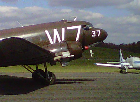
Around 1330 a C-47 was stopping at KWAY for fuel enroute to Geneseo, NY from Fort Benning, GA where it was used in Regimental ceremony. He did a nice low pass then wheel landed gently on runway 26.


With this guy on the ramp there wasn't much more that would happen on the Chief today.
I decided to fly the Cessna 205 back east so I can take it to Scranton this week for a potential buyer to check out. I planned on taking off no later than 4 on Saturday but when I arrived at the hangar the nosewheel was nearly flat. I couldn't get the air pump to work and after lots of airplane moving and door shoving had to put everything back.
I finally got the pump working and filled the tire with air, but by then it was after 5 and I didn't look forward to a night flight after such a long day. Janet called her friend Jan and she and Scott graciously offered us a room for the night.
We enjoyed a wonderful steak dinner and and evening with Scott and Jan and Andy and Brenda (who live across the street) and turned in late (after 11). I set my alarm for 0600 and it came early!
As I loaded up the car (Janet would drive the car back, I would leave the truck at the airport and fly the 205 back home), I looked up to see stars and moon -- a crystal clear morning. A call to Flight Service gave me some bad news -- Lancaster (5 miles from my destination at Smoketown) was below minimums with 1/4 mile visibility. I haven't flown much IFR this year so am not current to fly IMC. It would have to be VFR for me.
The fog sounded like it was east of Altoona, though so I decided to launch and see how far east I could get.
The airplane started on the second attempt and ran smoothly after a minute warm up. A double check of all systems, a roll out onto Runway 23, and a nice steep climb into the cool, clear air helped me quickly forget all the other work required just to have this privilege.
Somerset was clear, so I elected to refuel at Somerset to wait out the fog. A lineman helped me refuel (unusual these days of self-serve pumps) and I put 30 gallons in ($5.00/ gallon -- a bargain these days).
While waiting a very nice Cessna 206 ( a later model of the airplane I was flying) showed up. It was a Pennsylvania State Police aircraft. The pilot asked me if I was doing pipeline patrol, but I
told him I was ferrying the 205. He said they'd be just south of the airport doing "speed enforcement" -- Beware turnpike travelers!
I checked the KLNS ATIS by phone a few times. When the METAR changed from 1/4 mile visibility to 1/2 it indicated the fog was lifting. By the time I flew the hour out there Smoketown should be VFR. If not, I could divert to the nearest VFR field.
I took off from Runway 25 and depart from midfield downwind towards Indian Lake to the east. I was flying the route I had planned for the Chief. It would be good reconnaissance in a fully equipped GPS aircraft before flying it with just a compass, watch, and map.
Indian lake disappeared under my right wing. Ahead was the Flight 93 Memorial site -- it looks far more groomed then when I visited it on September 20th, 2001.
I maintained a steady compass heading of 92 degrees and soon was nearing the Bedford Aiport (KHMZ). The AWOS there reported 1/4 mile visibility in fog. I was 1500' above it in severe clear.
The next 46 mile leg was the longest without clear landmarks - this would be pure dead reckoning. I maintained heading and watched the turnpike disappear behind the endless central Pennsylvania ridges. I throttled back to 21" manifold pressure and 2200 RPM at 3500', skimming the ridgetops. The airplane loped along at 125 MPH airspeed, 130 knots ground speed. I was in no hurry since I needed time for the fog to lift.
After a while the turnpike reappeared on the right as it followed the valley with the ridge clear to the south. As I flew eastward the highway disappeared after a bend. I checked my chart and confirmed I was about to fly over the twin tunnels (Kittaniny and Blue Mountain) that I'd planned as a checkpoint.
I changed heading to 110, and ahead the sky had a high overcast to the south and a layer of cloud at ground level. I was in haze at 3500' so climbed to 5500' to be at VFR altitude and above the restricted visibility. I called Harrisburg Approach and asked for Traffic Advisories. Some carriers were shooting the ILS at Harrisburg and it sounded tight. I could still see the ground, though, and had plenty of fuel (70 gallons on board when I took off from Somerset) so figured I would divert to York or even Hagerstown, MD if Lancaster was still IMC.
I watched my planned checkpoints roll underneath -- Interstate 81, Route 15, Gifford Pinchot Lake, Interstate 83, the Susquehanna River...
By now it looked clear but hazy over Lancaster so I elected to cancel advisories and begin the descent to Smoketown. Lancaster ATIS had a special weather statement that visibility was now 2 miles in mist, but from my vantage point of 3000' it was clear with just some patchy fog in spots.
I skirted the southern edge of Lancaster city then turned towards Smoketown. The radio was quiet but I did some S turns to check for traffic and lose some altitude. Downwind, base, final, 40 degrees of flaps and some slip and I touched down just past the numbers on 28.
I'm pretty tired from a couple of busy days and short nights, so I'll go for an easy 20 mile bicycle ride, take a shower, and relax watching the Steelers play at 4:15.
Alas, there's still plenty more to do on N24286 -- one of the exhaust manifold threads was stripped and thus needs a tap to re-thread, and there is still some assembly required before we can hang the engine on its mount.
I ran around Waynesburg looking for a rare 1-9/16th, 16 threads per inch tap. Even the machine shop couldn't find one, so John will run it up to Washington this week to re-thread.
The engine looks good, though. All valves and springs, rockers, etc are fine and to original spec. The new pushrod tube seals worked perfectly and are nicely seated. The new cylinder head gaskets fit right and sealed under book torque. So far, so good!
 |
| N24286 Ready for inspection! |
Around 1330 a C-47 was stopping at KWAY for fuel enroute to Geneseo, NY from Fort Benning, GA where it was used in Regimental ceremony. He did a nice low pass then wheel landed gently on runway 26.
 |
| Low pass at Waynesburg |
 |
| Wheel Landing on Runway 26 |
 |
| An image from the Past |


 |
| Setting up chocks for a short layover on the ramp at KWAY |
I decided to fly the Cessna 205 back east so I can take it to Scranton this week for a potential buyer to check out. I planned on taking off no later than 4 on Saturday but when I arrived at the hangar the nosewheel was nearly flat. I couldn't get the air pump to work and after lots of airplane moving and door shoving had to put everything back.
I finally got the pump working and filled the tire with air, but by then it was after 5 and I didn't look forward to a night flight after such a long day. Janet called her friend Jan and she and Scott graciously offered us a room for the night.
We enjoyed a wonderful steak dinner and and evening with Scott and Jan and Andy and Brenda (who live across the street) and turned in late (after 11). I set my alarm for 0600 and it came early!
As I loaded up the car (Janet would drive the car back, I would leave the truck at the airport and fly the 205 back home), I looked up to see stars and moon -- a crystal clear morning. A call to Flight Service gave me some bad news -- Lancaster (5 miles from my destination at Smoketown) was below minimums with 1/4 mile visibility. I haven't flown much IFR this year so am not current to fly IMC. It would have to be VFR for me.
The fog sounded like it was east of Altoona, though so I decided to launch and see how far east I could get.
The airplane started on the second attempt and ran smoothly after a minute warm up. A double check of all systems, a roll out onto Runway 23, and a nice steep climb into the cool, clear air helped me quickly forget all the other work required just to have this privilege.
 |
| Final Approach to Runway 25 at Somerset |
 |
| On the ramp at SG9 |
 |
| Somerset County Airport |
While waiting a very nice Cessna 206 ( a later model of the airplane I was flying) showed up. It was a Pennsylvania State Police aircraft. The pilot asked me if I was doing pipeline patrol, but I
told him I was ferrying the 205. He said they'd be just south of the airport doing "speed enforcement" -- Beware turnpike travelers!
I checked the KLNS ATIS by phone a few times. When the METAR changed from 1/4 mile visibility to 1/2 it indicated the fog was lifting. By the time I flew the hour out there Smoketown should be VFR. If not, I could divert to the nearest VFR field.
I took off from Runway 25 and depart from midfield downwind towards Indian Lake to the east. I was flying the route I had planned for the Chief. It would be good reconnaissance in a fully equipped GPS aircraft before flying it with just a compass, watch, and map.
 |
| Fog filled most of the valleys |
 |
| The Fall colors were past peak in the mountains |
 |
| Fog, fog, fog... |
 |
| Seven Springs Ski Resort |
Indian lake disappeared under my right wing. Ahead was the Flight 93 Memorial site -- it looks far more groomed then when I visited it on September 20th, 2001.
I maintained a steady compass heading of 92 degrees and soon was nearing the Bedford Aiport (KHMZ). The AWOS there reported 1/4 mile visibility in fog. I was 1500' above it in severe clear.
The next 46 mile leg was the longest without clear landmarks - this would be pure dead reckoning. I maintained heading and watched the turnpike disappear behind the endless central Pennsylvania ridges. I throttled back to 21" manifold pressure and 2200 RPM at 3500', skimming the ridgetops. The airplane loped along at 125 MPH airspeed, 130 knots ground speed. I was in no hurry since I needed time for the fog to lift.
After a while the turnpike reappeared on the right as it followed the valley with the ridge clear to the south. As I flew eastward the highway disappeared after a bend. I checked my chart and confirmed I was about to fly over the twin tunnels (Kittaniny and Blue Mountain) that I'd planned as a checkpoint.
I changed heading to 110, and ahead the sky had a high overcast to the south and a layer of cloud at ground level. I was in haze at 3500' so climbed to 5500' to be at VFR altitude and above the restricted visibility. I called Harrisburg Approach and asked for Traffic Advisories. Some carriers were shooting the ILS at Harrisburg and it sounded tight. I could still see the ground, though, and had plenty of fuel (70 gallons on board when I took off from Somerset) so figured I would divert to York or even Hagerstown, MD if Lancaster was still IMC.
I watched my planned checkpoints roll underneath -- Interstate 81, Route 15, Gifford Pinchot Lake, Interstate 83, the Susquehanna River...
By now it looked clear but hazy over Lancaster so I elected to cancel advisories and begin the descent to Smoketown. Lancaster ATIS had a special weather statement that visibility was now 2 miles in mist, but from my vantage point of 3000' it was clear with just some patchy fog in spots.
I skirted the southern edge of Lancaster city then turned towards Smoketown. The radio was quiet but I did some S turns to check for traffic and lose some altitude. Downwind, base, final, 40 degrees of flaps and some slip and I touched down just past the numbers on 28.
I'm pretty tired from a couple of busy days and short nights, so I'll go for an easy 20 mile bicycle ride, take a shower, and relax watching the Steelers play at 4:15.
Tuesday, October 18, 2011
No Electric, IMC
[I originally posted this on a pilot web board after it happened in July 2010]
--------------------------------------------------------------------------------
I learned the hard way why we train in degraded modes.
I planned to sit right seat with an IR student down to NC and I was going to fly it back. This was a very well equipped Cessna 205 with thorough annual completed a few weeks ago.
I arrived early and watched ceilings lower as lines of widely spread thunderstorms crawled through the area. We had XM and Stormscope on board, so we'd have updated info. I did a thorough weather brief, and figured we'd be in front of the line as long as we were airborne by 0600.
Preflight, load up, call Pittsburgh Approach a few times on the cell for an IFR clearance, finally get through. Release time 0620 -- That will work.
Startup, taxi down, runup, everything good -- yet the XM weather on the Garmin handheld still shows "Waiting for data." Oh well.
Stormscope shows lots of activity just to the south. We'll have to ask to deviate east once we contact Center.
We launch and within a minute are in IMC, and despite winds in the 20s, it's not too rough. Still, the left seater isn't doing a very good job keeping wings level. I point to the attitude indicator. We roll through level and then head the other way. Such is learning -- I'll only interfere if bank exceeds 15 degrees or so.
I try calling Cleveland center -- nothing. Hmmm. We usually make contact by now...
Lots of bright lights on the Stormscope. We need to deviate soon. The closest strike is within 25 miles.
Try again. We're at 3500, cleared to 5,000 feet, but still no response from Cleveland Center.
Hmmm...
"Let's try Pitt approach..."
Silence.
Clarksburg Approach?
Silence.
I reach for the landing lights, switch them on then off and watch the Ammeter needle center slowly.
Hmm....
I glance at the panel. We're in a 30 degree bank.
"Let's turn on the A/P while I figure out this comm problem..."
"OK..." Relief. Wings level.
I fiddle with the radios, try different frequencies -- nothing. Not a peep.
Very strange.
I look at the AI -- We're in a 30 degree bank!!
What??!
I switch off the A/P, grab the yoke, tell my student "My airplane."
I look over and try to figure out why the A/P is freaking out. But while doing that I don't correct the bank, then hear the Voice in My Head -- "FLY THE AIRPLANE!"
Oh yeah... wings level, descent arrested.
Now -- where are we?
I switch off the transponder, secondary comms, all lights. The panel-mounted Garmin 430 is still working, so is the 496 handheld.
"Set up Direct Connellsville on the handheld." My left-seat co-pilot complies.
I dial in the Localizer 5 Approach into KVVS on the 430. We have no radio reception, but the overlay will provide enough guidance to get us down under this cloud.
We are over terrain that reaches 3000' -- I'm at 3500'.
I climb to 4000, then fly direct to the initial approach fix displayed on the GPS. The VOR needles won't work since we have no power in the radios.
The little airplane shows up on the magenta line. We're on battery power only and the handheld has the same approach setup. I do the full procedure turn, descending to the approach altitude, We're established, but not on any needle -- no signal.
All we have is the GPS guidance. This is not a "legal" GPS overlay approach.
So be it.
We break out at 2100 MSL -- a few hundred feet above Minimums (the terrain here is 1400-1500' above sea level). Thank you Lord for sight.
I fly a left downwind, "You want to land it?"
"No, you take it."
I land a bit fast and long but smoothly in the gusty 20+ knot wind. I let him taxi back because I had enough.
Once stopped, I hop out and call ATC to cancel.
They seem as relieved as we are: "Yeah, we were wondering what happened..."
We put the airplane away, open up the cowling -- holy crap -- there are shards of belt everywhere. Nice.
I drove home and crawled back in bed and slept for a few hours, thankful to have another day to think about how many mistakes I've lived through.
Lessons learned?
- Make sure you can hear some transmissions before taking off into IMC. Sure, we were on a quiet little field early in the morning, but other ATIS would have been broadcast at that time (even if ours was out of service).
- The A/P cannot be relied on to reduce pilot load when there are system problems.
- A handheld GPS device with independent battery and approaches is a lifesaver.
- Practice emergencies. They don't happen when you expect them, and are more likely when you don't expect it.
- The time to panic is after you're on the ground, pushing the airplane back in.
- This stuff is for keeps.
Monday, October 17, 2011
Wind, wind, wind....
We've been in the midst of a steady wind here the past few days. It feels like our corner of Pennsylvania was dropped onto the great plains.
Hopefully the winds will calm down by the weekend so I can fly the Chief home!
Hopefully the winds will calm down by the weekend so I can fly the Chief home!
Thursday, October 13, 2011
Online Flight Planners
There are now several decent online flight planners to use. Some free, some with a nominal charge.
While I still enjoy laying out sectionals and drawing with a pencil, I also like to experiment with different routes, check on airports, and double-check my pencil and paper work with computer-aided calculations.
I provide a summary that looks like this:
Flight Planner Name
So here is my biased, slightly informed review of Flight planners I have used:
(If there is one I should use, send me a link!)
AOPA Flight Planner
NavMonster
EAA Flight Planner
SkyVector
Runway Finder
FlightAware
FltPlan.com
While I still enjoy laying out sectionals and drawing with a pencil, I also like to experiment with different routes, check on airports, and double-check my pencil and paper work with computer-aided calculations.
I provide a summary that looks like this:
Flight Planner Name
- Cost?
- Ease of use: 1-10 scale, 1 being stupid hard, 10 being 5 year old easy, the rets is somewhere between those extremes
- Accuracy: How good is the information produced?
- Output usefulness in Flight: Does it provide kneeboard print outs et cetera that are actually useful in the cockpit?
So here is my biased, slightly informed review of Flight planners I have used:
(If there is one I should use, send me a link!)
AOPA Flight Planner
- AOPA membership required
- Ease of use: 9, this is the easiest by far, in my opinion.
- Accuracy: 8, it's pretty good, though closed airports still show up as options (Seven Springs, for example)
- Output usefulness in Flight: 7, there's a nice nav board with all the requisite data, but a print out of all airport info along the route of flight would be much awesome.
NavMonster
- Free
- Ease of use: 8 -- this is fairly easy and intuitive, but page changes lose context.
- Accuracy: Seems to provide good info, but lack of sectionals is disappointing.
- Output usefulness in Flight: 8, the trip kits are the best of all web-based planners.
EAA Flight Planner
- EAA membership required
- Ease of use: 5 -- there are simply too many varied screens, with all sorts of suggestions that you update to "Premium." Oh, ok. Maybe not
- Accuracy: Seems to provide good info.
- Output usefulness in Flight: 8, the trip kits are nice, though paper and ink hogs.
SkyVector
- Free, registration required
- Ease of use: 7, pretty simple, but limited in info and too many overlay screens that lose context ("what just happened? OH! There's a tab -- over what I was doing...")
- Accuracy: Seems ok -- sectionals are current.
- Output usefulness in Flight: N/A (Haven't used this in flight)
Runway Finder
- Free, registration required
- Ease of use: 8,
pretty simple,and somewhat easier than SkyVector.
- Accuracy: Seems ok -- sectionals are current.
- Output usefulness in Flight: N/A (Haven't used this in flight)
FlightAware
- Free, registration required
- Ease of use: 4, limited in info and too many changing contexts. I lost interest in trying it, quite frankly.
- Accuracy: Seems ok -- sectionals are current.
- Output usefulness in Flight: N/A (Haven't used this in flight)
FltPlan.com
- Free, registration required
- Ease of use: 4, limited in info and too many changing contexts. I lost interest in trying it, quite frankly.
- Accuracy: Seems ok -- sectionals are current.
- Output usefulness in Flight: I haven't used fltplan.come stuff in flight for at least 5 years. It was good then, but newer web-based planners have made this obsolete for my use.
One of the oldest, but showing its age. The interface is cluttered, errors are not adequately flagged (you are not alerted and thus cannot proceed at certain steps), the aircraft performance list is limited and there is no way to build a custom aircraft entry.
I used it years ago, but it's off my list of flight planners.
Flight Prep
Are you kidding? never in a million years.... 2011 Annual
This year's maintenance focused on the engine. While there were no major oil leaks or power problems, there was one nuisance leak and I simply wanted the engine opened up and inspected thoroughly and all gaskets replaced. One pushrod tube seal had a leak and it wasn't getting better. It dripped from the seal onto the exhaust pipe - not a good thing.
Once we pulled the engine we found one cylinder had blow-by. It's hard to tell if it's constant or merely on startup (cylinder may warm and compress gaskets reforming the seal between the head and the base). So back in May we pulled the engine off and John opened it up. The news was very good -- all valves, rings, pistons, lifters -- the works -- were in good shape, with no abnormal wear or deformation.
I ordered one set of gaskets and manufactured another (.020 copper gaskets) The pushrod tube seals were another matter. One quote was $26 each -- for 16 (these seals are mere 1" rubber O rings). So I tried owner manufactured, but could not get the lip right.
Finally I found a source for 14 in Atlanta for $14 each. I ordered the balance from Tulsa, OK for $24.50 each. So John is re-assembling the engine this week. This means all hoses, gaskets, lines, and mounts will be new. All spark plugs will be mounted in heli-coils for added security.
Of course we'll pull all the inspection plates, floor boards, etc, but this should be a simple annual after the work we've accomplished in the past 18 months.
I'm looking forward to test flying it. If all checks out I'll fly it across Pennsylvania to its new home!
Tuesday, October 11, 2011
Neat resource! WW2 Naval booklet for instrument pilots in training.
http://aviationshoppe.com/manuals/flight_thru_instruments/naval_flight_manual.html
Latest Update
I talked to John Strope, my patient and knowledgeable A&P who is putting my engine back together with all new gaskets.The schedule right now is to get the engine on the airframe this Saturday, with the Annual complete next week.
That's fine since the current forecast is for 25-35 MPH winds on Saturday and 20 MPH winds Sunday. No fun flying an 800 lb airplane in those conditions! If it's not too bad I may fly the Cessna 205 out for a potential buyer in Scranton, PA.
So realistically some time next week the Chief wil come home! I've done all the flight planning. KWAY to S37 (Somerset, PA), stop and re-fuel after 45-50 minutes. Then S37 to S39 via KHMZ, then the Sideling Hill Turnpike rest Area (very good landmark), then remain north but parallel to the Turnpike. Once I clear the last tunnels, direct to S37 (Smoketown) for 2 more hours in flight.
There are two small restricted areas just south of the route of flight that I need to avoid (they are part of the Letterkenny Army Deport Test Range). Staying north of the turnpike until all tunnels are cleared will assure plenty of clearance.
Tuesday, October 4, 2011
A Long Stretch
I was finally able to secure the last remaining gaskets for my antique engine. 4 have arrived at Strope Aviation and the rest (12 more) should be there today. I still have one of the pushrod tubes (used it to measure and cut ill-fated gaskets) but will be back out west this Friday.
John thinks he can get the engine back together this week, which means I may be flying it home next weekend!
My new airport home is Smoketown Airport,\ (S37) just east of Lancaster on Old Philadelphia Pike. It's about a 15 minutes drive from our place in Mount Joy. It's a small-town airport with enough level turf to make it perfect for my antique taildragger.
I know the area well and am looking forward to low and slow flight over the endless patchwork of Lancaster County farms.
Subscribe to:
Posts (Atom)